
本教程是关于Unity中GPS地理信息应用技术视频教程 Unity: Integrating GPS and Points of Interest,时长:3小时57分,大小:1 GB,MP4高清视频格式,教程使用软件:Unity,附源文件,作者:Diego Herrera,共27个章节,语言:英语。
Unity是一款跨平台的游戏开发工具,从一开始就被设计成易于使用的产品。作为一个完全集成的专业级应用,Unity还包含了价值数百万美元的功能强大的游戏引擎。Unity 4作为一个游戏开发工具,它的设计主旨就是让你能够创建令人惊讶的游戏。如果你之前尝试过Unity,请查看Unity 3都做了哪些更新。如果你是第一次尝试,那就好好看看吧,看Unity都能为你带来什么。Unity作为一种开发环境,可让你脱离传统的游戏开发方式,以一种更简单的方式专注于你的游戏开发。开发网络游戏、移动游戏、单机游戏,Unity都能完全胜任。
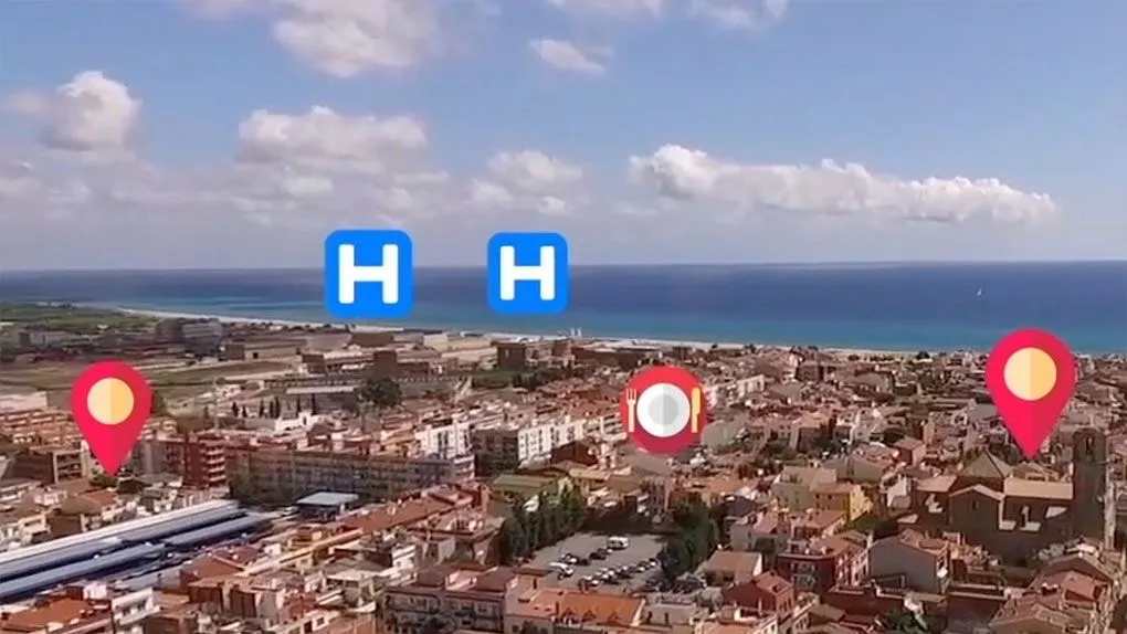
Geographic data is at the heart of much of the large-scale augmented reality work out there, but adding it to projects takes finesse. In this hands-on course, instructor Diego Herrera lays out the process, showing beginners how to use GPS inside Android and iOS applications. Throughout the course, Diego details how to load information from the Google Places API and process the JSON code successfully inside Unity. Learn how to set up an augmented reality camera, as well as how to build a fully-functional application that can sort results by distance.
Topics include:
Setting up an AR camera
Building a scrolling menu
Creating a scene controller
Using Unity to load data from a website URL
Refactoring code
Populating a virtual object with JSON data
Calculating distance using GPS
Sorting results
「©版权声明」易光易影(www.yigyiy.com)收集的资源仅供内部学习研究软件设计思想和原理使用,学习研究后请自觉删除,请勿传播,因未及时删除所造成的任何后果责任自负。如果用于其他用途,请购买正版支持作者,谢谢!若您认为 易光易影(www.yigyiy.com)发布的内容若侵犯到您的权益,请点击此处侵权反馈。我们将第一时间配合处理!


评论0